
In the fast-paced world of construction, few things are as vital as pinpointing the exact locations of underground utilities. The safety of your dedicated crew, the seamless efficiency of your projects, and your ability to stay in compliance with ever-evolving regulations all hinge on this fundamental knowledge. That’s why we are thrilled to introduce you to Spearhead’s new GPS/GIS-based Subsurface Utility Mapping Service, the latest in our growing list of service offerings.
The Challenge: When Utility Markings Vanish
Have you ever found yourself frustrated by the sight of your utility markings disappearing by the movement of heavy construction equipment or being swallowed by the grading process? It’s a common headache in the construction industry, one that can lead to unwelcome delays, ballooning costs, and most critically, safety hazards lurking on your job site. But worry no more – our Utility Mapping Service is the antidote you’ve been searching for.
The Solution: Innovating with GPS/GIS
Our GPS/GIS-Based Utility Mapping Service goes far beyond the confines of traditional utility locating and marking. We don’t merely mark utilities; we create a comprehensive, permanent, and regulation-compliant record of their exact locations.
Here’s the nitty-gritty of how it works:
1. Precise GPS/GIS Technology

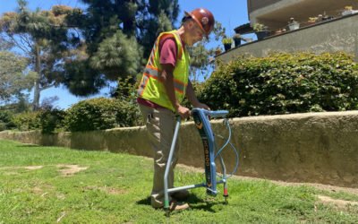
Subsurface Utility Mapping - data input in the field using the Trimble R2 GNSS receiver
Thanks to advances in GPS/GIS technology, many cost-effective solutions are now available. We harness state-of-the-art GPS/GIS technology to accurately map the locations of your underground utilities. This level of accuracy guarantees that you’ll always have the most reliable information right at your fingertips.
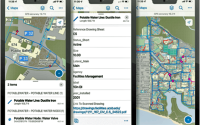
2. KMZ and SHP File Integration
Upon completion of our service, you will receive a KMZ (Keyhole Markup Language Zipped) file that enables you to effortlessly view your utilities in Google Earth. This user-friendly format can be readily shared with your construction crew on their mobile devices or computers, facilitating seamless collaboration. Additionally, we provide SHP files that can be seamlessly integrated into your CAD drawings.
3. Improved Safety
Accurate utility mapping isn’t just about convenience; it equates to enhanced safety on your construction sites. With our service, your crew can work around utilities confidently, significantly reducing the risk of utility strikes, accidents, and injuries.
4. Enhanced Efficiency
Say goodbye to the frustration of vanishing markings. Our detailed records ensure that you’ll never have to worry about relocating and remarking utilities again. This translates into improved project efficiency and fewer frustrating delays.
5. Regulation Compliance
Are you aware of California Regulation 4216.3(a)(5)? As of January 1, 2023, it mandates that all new subsurface installations must be mapped using a geographic information system (GIS) and be maintained as permanent records. With Spearhead’s Utility Mapping Service, compliance becomes a breeze, ensuring that your operations seamlessly align with legal requirements.

Spearhead Utility Mapping - 2D KMZ output file created with Pointman Mobile Underground Utility Mapping Software and opened in Google Earth on the web
The Benefits: Your Safety, Efficiency, and Peace of Mind
Investing in our GPS/GIS-Based Utility Mapping Service offers a treasure trove of advantages:
- Safety: Safeguard your crew and forestall costly accidents by having accurate utility data at your disposal.
- Efficiency: Minimize downtime and delays by eliminating the need for redundant utility locating and remarking.
- Collaboration: Foster a culture of improved teamwork with easily shareable utility maps accessible to all team members.
- Regulation Compliance: Stay ahead of the curve by complying with the latest regulations, steering clear of penalties and legal entanglements.
- Peace of Mind: With our comprehensive records, you can approach every project with confidence, secure in the knowledge that you possess the finest utility data available.
The Next Step: A Safer, More Efficient Future
In the ever-evolving realm of construction, staying ahead of safety regulations and ensuring project efficiency is paramount. Our GPS/GIS-Based Underground Utility Mapping Service fulfills all your requirements, providing the peace of mind and reliability necessary for excellence in your projects. Bid farewell to the frustration of vanishing markings and usher in a safer, more efficient future.
Contact us today and, together, we’ll take your construction projects to the next level!

0 Comments